|
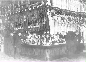
ST LAWRENCE MARKET SATURDAY MORNING... If
you go the St. Lawrence Market this Saturday morning you may notice some changes from this photo taken 100 plus years ago.
At this butcher shop note there is no refridgeration, the way things are displayed, the prices, and the sawdust on the floor
to absorb the blood from the slaughtered animals. This picture is of the William Davies company. This is a retail outlet but
they were one of the slaughter houses located down near the Distillery. Today you know it as Canada Packers.
HOW DID LIBERTY VILLAGE GET ITS NAME? When Toronto was established in 1793 as the village of York a Fort
was built at the entrance to the bay called Fort York. It still stands not on the water's edge as it had in the beginning
but now surrounded by land fill and at a distance from the lakes edge. The land to the west of it was a military reserve called
the Garrison lands. Here the army would drill and practice maneuvers. In the 1850s, both the Toronto, Grey and Bruce Railway and the Great
Western Railway laid tracks across the community, cutting it off from rest of the city and altering plans to develop the area
for residential purposes. Instead, this area became home to several factories and institutions, over the years. The
area's proximity to the railway tracks led to its growth as an industrial area. In 1884, John Inglis and Company opened a
factory to manufacture heavy machinery, boilers, and later, electrical appliances. In 1891, Massey-Harris (later Massey Ferguson)
built a factory to produce agricultural implements. Other companies which established in the late 19th century included Toronto
Carpet Manufacturing, St. David’s Wine, and Ontario Wind Engine and Pump. Industry continued to flourish during
the early 20th century due to the area's excellent railway access and many spur lines, as well as a plentiful labour supply
from nearby Parkdale. New companies included Brunswick-Balke-Collender (manufacturer of billiard tables and bowling alleys),
Irwin Toy, Canada Metal, Simmons Bedding, Hinde and Dauch Paper, and Sunbeam Incandescent Lamp (later Canadian General Electric). Many
of the factories produced armaments, bombs, and weapons during both world wars, and much of the soil pollution in the area
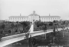
dates from those periods. After WWII the industries moved out and the area fell on hard times. Two prisons opened in the area
including the Toronto Central Prison for men, opened in 1873, and the Andrew Mercer Reformatory for Women (on the site of
today’s Lamport Stadium), opened in 1878 for women convicted of "vagrancy", "incorrigibility", or "sexual precociousness."
Provincial Secretary William John Hanna forced the closure of Central Prison in 1915, and all its buildings were demolished
except for the paint shop and chapel. "Liberty Street", for which Liberty Village is named, was the first street both male
and female convicts would walk once freed. Just after the beginning of 21st Century this area was developed as Liberty Village.
The name was introduced as a positive 'brand' by the property owners and developers in the area in conjunction with the City
of Toronto. The neighbourhood aims to distinguish itself from Parkdale, which now begins west of Dufferin Street. Its location
is considered one of its finest assets being a 15-minute walk to the Lakeshore, 20-minute streetcar ride to the financial
core and a 20-minute walk from the entertainment/fashion/gallery districts of King St. West. Partly because of this, Liberty Village has experienced phenomenal
growth from 2004 to the present in terms of new condos/lofts, office space, a new park, and a multitude of new shops and restaurants.
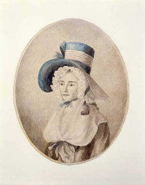
WHO WAS ELIZABETH POSTHUMA GWILLIM…AND HER 3 POODLES? You know her as Lady Simcoe the wife of our first Lt. Governor John
Graves Simcoe. She was born in 1762 at Whitchurch, Herefordshire, England. Her mother died at child birth and her father had
died months earlier, hence the middle name of Posthuma, meaning born after the death of her parents. She was raised by her
aunt and uncle, an admiral in the British Navy. In 1782, she married Simcoe when she was 17 and he was 31. He became the first Lieutenant-Governor
of Upper Canada. The couple arrived in Canada in 1791 leaving four of their six children in England. The returned to England
in 1796. Simcoe died in 1806; Lady Simcoe lived the remaining 44 years of her life in widowhood. She died in 1850 and her maiden name was applied to the townships of
West Gwillimbury in Simcoe Country, and North Gwillinbury and East Gwillimbury in York. The townships of Tiny, Tay and Flos
in Simcoe County were named for her three poodles. There is a book of "The Diary of Mrs. John Graves Simcoe" that details the four years of Simcoe's tenure as Lt. Governor.
She also did over 90 watercolours images of Upper Canada.
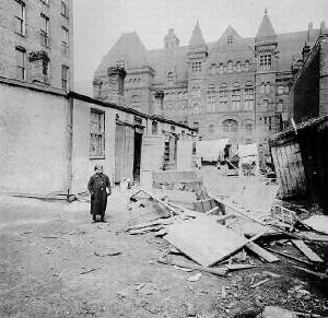
SOMETIMES CHANGE IS FOR THE BETTER…
This
picture was taken at the beginning of the 20th
century. Its point of view is from where the current new city hall is looking
east. You will note the slum that existed then. This area was called the
"Ward" not in the political sense but in the sense of a welfare ward.
It was the immigrant reception area for Victorian Toronto.
The majority of people living in this area
were Jews who
found work in the Eaton factories in the area. There ...was also a sizeable
Italian population and other groups like blacks, Hungarians, and Chinese. The
Old City Hall opened in 1900 and the Mayor and others were embarrassed to have
the slum located next to the City Hall.
As
a result the city and businesses in the area started a
building program that would drive out the immigrants in the area. First among
these changes was the building of the Toronto General Hospital that took out
many homes. Others included by Sick Kids, the Armoury, the Registry Hall. These
drove out the Jews who resettled along Spadina while the Italians settled along
College Street.
SOME PERSONAL HISTORY... BEFORE THE O'KEEFE CENTRE
WAS THE
TORONTO WHOLESALE FOOD TERMINAL ... Both my paternal
and maternal grandparents came over at the beginning of the 20th century to Toronto. If you were Italian then you either dug
a ditch, cut hair, polished shoes, played a musical instrument or sold bananas. In the case of my paternal grandfather Vito
Genova he sold bananas. He originally would pick up his bananas from the railway cars south of the St. Lawrence market and
peddle them by cart around the city. He then moved on to a rented store and finally to a store he owned. That store was at 1582 Bloor St West in the High Park area. He catered to the
a neighbourhood that was WASP. My father followed in his footsteps and I of course as a little guy worked in the store with
a white apron so far back that it is out of my memory when it all started. That's where I grew up and attended Keele Street
Public School. My father during the summer would take me to
the wholesale market to hand pick the cases of fruits and vegetables we would sell. For me at 4 a.m. in the morning when it
was still dark we would head off to this exotic world of characters located where the O'Keefe Centre, oh I am showing my age
now known as the SONY Centre is. I saw my first black man, heard foreign tongues of Pollocks, Yiddish, Greek and more. I ate
a half moon bagel like bread, grilled and lathered with butter and drank chocolate milk. Still do to this day and it hasn't
killed me yet. The wholesale market had previously been the
a railway shed for the Grand Trunk RR but with the building of the Union Station it was surplus. The market spread out to
buildings located in the five-acre block of King Street East, Market Street, Front Street and Church Street, northwest of
the St. Lawrence Market building. Fifty-six wholesale and related firms moved to the new terminal from the old bloc Attached are some pictures of that wholesale market that burnt down in 1951 with
me witnessing its end. When they moved in 1954 it was to what you now know as the Ontario Food Terminal that you see when
leaving town on the QEW at Park Lawn Ave.
MEET MR. JOSEPH BLOORE... Today the "E" has been dropped but it is the same man. Bloor was a tavern keeper around the St. Lawrence Market
originally and then moved up to the Yonge/Bloor area. He built a house located on Bloor Street on the south side opposite
where the Bay is today. He opened a Brewery in the Rosedale Ravine and dammed the creek there. If you go to Sherbourne Street
to cross the ravine if you stop in the middle and drop a loonie you would hit the roof of the old brewery. He was a sour faced
man but it didn't stop him from partnering up with Botsworth Jarvis and becoming land speculators in the development of the
Village of Yorkville. This month is the 153 year of his death. His tombstone reads that he was an exemplary and useful Christian
who calmly fell asleep in Jesus at the age of 74.
THE UNAPPRECIATED STORY
OF ALLAN GARDENS
In downtown Toronto at Jarvis and Carlton is a park with greenhouses. It is called Allan Gardens. It is not fully appreciated
by the citizens of Toronto but it is popular with gardeners, artists, photographers, visitors and those who appreciate beauty.
The main greenhouse is a huge dome of cast-iron and glass and is called the "Palm House". Inside it are bamboo, bananas,
and a large Screw Pine that tower above your head creating the feeling you are in a jungle setting. In addition there are
five other greenhouses comprising over 16,000 square feet. Each greenhouse has a different selection of plants that are dictated
by the temperature in each greenhouse. They are all interconnected. The greenhouse directly south is called the "Cool House"
with a waterfall, citrus trees, and a Kashmirian Cypress. There is also with a pond with a statue from Greek mythology Leda
and the Swan. You then enter a warm, humid tropical paradise with orchids and bromeliads and a small hut with a functioning
waterwheel at its side. In my case when I was photographing it I could not see through my camera lens. It took me a minute
or two to realize my lens had fogged up because of the humidity. The name of this greenhouse is of course the "Tropical House".
North of the "Palm House" you find a less humid but tropical house with different kinds of ginger, datura and hibiscus. Beyond
that is the "Cactus House" with a wide variety of cacti and succulents. One additional greenhouse is beyond this and is used
to develop a love of gardening with children. These additional "Houses" were either new or taken from other locations and
added on the "Palm House". One of these came from the CNE and the other a greenhouse that was part of the U of T that was
originally located at the north west corner of University and College. In 1902 a statue to the Scottish poet Robert Burns
was added and still stands at the east end of the park.
What you see today is not what was originally built here. The first structure that existed at Allan Gardens was a pavilion
and a conservatory or greenhouse. The pavilion was 100 feet long, east to west and 60 feet in wide. The structure was made
of cedar pillars, with the bark still on them and topped off by a tiered roof. Inside was seating for 1,500. It was a venue
for gala balls, promenade concerts, flower shows, conventions, and speakers. One of the speakers here was none other than
Oscar Wilde. The conservatory was added shortly thereafter to show flowers. It was of great importance to the citizen's of
Toronto and the Prince of Wales was invited to do the honors of opening it. That same year another famous Toronto park was
also opened. We know it today as Queen's Park.
The original park itself
was 5 acres had planted hundreds of trees and shrubs, ornamental flower beds of every size and shape. It had many artificial
mounds and the grounds were extensively sodded. It was framed by the remains of a maple and beech forest of five acres outside.
In addition other trees were planted such as black cherry, American beech, red oak, sugar maple and sassafras. Most are now
over a 100 years old today. The entire park was surrounded by a fence with entrance being on Gerrard Street. A large Iron
fountain was in the centre of the park with a system of meandering strolls through wooded areas for people to walk. When open
it was to be free to the public. The park is home to three varieties of squirrel, the gray, the black, and, unique to this
park, the red tailed black squirrel. The park is also home to the city's largest flock of pigeons, and a roving peregrine
falcon. The original structure burnt down in 1902. It took until 1910 for the new structure the current Palm House to be
opened.
Allan Gardens allows you as a visitor to visit around the world in 80 minutes. You have a chance to visit and see
the plants from cool temperate, warm temperate, and arid zone plants from different climatic regions of the world. You'll
find plants from Australia, Brazil, China the West Indies, Mexico, South Africa and the Himalayas. As I write this enewsletter
the temperature is -10 degrees Celsius and the snow is falling. One guess of where I am off to when I finish writing.
By the 1850's, industrialization and rapid growth had left the young city of Toronto with few opportunities for public
open spaces. Surprisingly the northern boundary of the city of Toronto was Queen Street running east and west. Yonge Street
divided the city into the east and west ends of Toronto. Above Queen Street to the next major east west concession of Bloor
Street were narrow two block wide lots running up to Bloor. Each lot was 100 acres and the Estate Home for each of these lots
was built near Queen Street so your nieghbour was a short distance away. Lot 1 and 2 were located at the Don River and the
numbering went from east to west. Lot 5 was William Allan's and he had purchased it 1819. His neighbour to the west on lot
6 was the Jarvis family living at Hazelburn.
William Allan was a poor Scots immigrant who
became a successful merchant, soldier and banker. He built an estate home called Moss Park. The home in a palatial Greek Revival
style was the envy and wonder of the citizen of York (Toronto). By 1830s orchards, ornamental plantings and a curving roadways
added to the attractiveness of Moss Park. William Allan had 10 children of which only one survived by the name of George William
Allan. When Allan Jr. married in 1846 his father gave him the northern half of Moss Park where he built a home north of what
is Allan Gardens called Homewood. He lived there until the death of this father in 1853. At this point he moved to Moss Park.
Allan Jr. went on to become a Toronto Alderman and then elected the 11th Mayor of Toronto. He was appointed a Canadian
Senator and served for 34 years. He also was appointed as Speaker of the House. He served on various boards at the local and
national level. Allan's interest were much broader then just politics and business. He was interested in Science, education,
culture and art. He was a Toronto Renaissance man presiding over the Royal Canadian Institute, the Toronto Conservatory of
Music, the Ontario Historical society and the Ontario Society of Artist. He was chancellor of Trinity College, and President
of the Upper Canada Bible Society. He sponsored two now famous artist. Audubon and Paul Kane. He commissioned Kane to do 100
oil painting for $20,000 to support him. With this money Kane decided to document in his paintings the disappearing life the
Canadian Aboriginal peoples.
Allan decided to develop the lands of Moss Park. His vision was from Queen Street north a street would lead to a garden
and on the other side of the garden another street. At the heart of this residential development of the north and south was
a park. However he never follow through with the private park but opted for a sort of combination private club and public
square. The ownership and character of this park changed over time. By 1856 he decided to give to the Toronto Horticultural
Society 5 acres of land at the heart of the park and an option for another surrounding five aces. This was to be raised by
the Club. In the end he gave this land also. George William Allan lived into the 20th century and died on July 24th, 1901.
It was then that the Horticultural Gardens was renamed Allan Gardens in his memory. His private philanthropy in creating a
public park had a similar story in the creation of High Park that again was a gift of private philanthropy by John Howard.
*I recently visited Allan Gardens to gain background for this article. If you would like to see a video of today's Allan
Gardens click on the following link.
https://www.youtube.com/watch?v=OPnklhAud6E
TORONTO'S OLYMPIC THORNCLIFFE SKI JUMP
Watching the Olympic Ski Jumping Events it is difficult to believe that ski jumpers from around the world once com¬peted
in the Leaside area at what was called the Thorncliffe Ski Jump. It was the home of the Toronto Ski Club (TSC) ski jumpers
that experienced considerable success in regional, national, North American and even International and Olympic ski jumping
events during the thirties and forties.
Ski jumping by a daring few had occurred in the twenties at High Park and later at the Summit Golf Club north of Toronto.
Soon they began to out-jump the hill with maximum jumps about sixty feet. The Toronto Ski Club decided to build a 40-meter
hill and settled on a site in Leaside on an unused portion of a hydro right-of-way. The spot was located at the east end of
Wicksteed Ave where it falls off into the Don Valley. Home Depot is on that street.
The jump and a smaller practice jump were completed in 1933 but in it was the Ontario Championships on February 10th 1934
that really started things off. It was estimated that jumps of 150 feet could be accomplished. Jumpers from across Canada
and the U.S. attended the event. However just as we are now experiencing at 2010 Winter Olympics the ski jump loomed big,
bare and dry on opening day.
What to do? Creative minds found a solution. As some of the skiers skated at the Varsity Rink, they were aware of the
over¬sized "ice shaver" used to keep the skating surface smooth. This was in the days before the iconic Zamboni
that now does ice surfaces. The rink was flooded with an extra inch and then the shaver worked all night and the shaved ice
was piled in huge ridges along the sides. One hundred tons of shaved ice was transported by truck and train to the ski jump.
There, fifty members of the Ski Club spread it over the hill and on the outrun. By the time of the jumping event the next
afternoon, conditions were viewed as perfect. Sounds familiar doesn't it.
The crowd that came out that day was about 10,000 people. One skier Tom McGoey should have been given a medal for bravery
that day who zoomed down the hill, misjudged the takeoff, landed on his head and was fortunately okay. The crowd loved it.
Over the following years local, provincial, national and international ski events were held. Many local athletes went off
to compete in the Olympics. World War II came along and a number of military jumps were organized but the jump was finally
dismantled during the war thus ending major ski jumping in the Toronto area.
Torontos Waterfront
By Bill Genova
At one time giant glaciers towered over our waterfront. They
were three times the height of the CN Tower. Later when these icy towers melted flora, fauna and animals appeared. Humans
quietly soft shoed through the forest on the lakes edge or glided softly in their canoes as they past the waterfront. A great
marsh was found at the delta of a River that came to the waterfront in the bay, and hunting was good. Their long houses and
palisade enclosures grew on the shore. Rival parties and Huron and Iroquois warriors stalked each other along the waterfront.
Time passed and the chanting song of the voyageurs and coureur
de bois echoed along the waterfront. Names that have since become historic, Etienne Brule, Father Brebeuf, Father Hennepin,
Jolliet, Champlain and LaSalle were familiar with the waterfront. The French also built forts along the waterfront but they
were abandoned after an epic battle was fought on the Plains of Abraham.
Soon Red coats appeared speaking with British, Scottish and
Irish accents. The booming of canons was heard in the bay as Governor Simcoe and his wife landed amidst great ceremony and
claimed this waterfront as part of a new capital. They established a small 10-block town called York on the eastern end of
the bay and built a Fort to the west to defend the harbour entrance.
This small community grew into a British Imperial Military
garrison. It had been established to protect these new British lands from former British subjects who had rebelled and won
their independence. These Americans as they were now called wanted this land as well and a war ensued. In 1812 they attacked
the nascent community of York and burnt its Parliament buildings terrorizing its small community that in total would fit into
a modern waterfront Condo building.
Peace finally came and the town grew more successful. Its
harbour filled with sailing ships and long fingered wharfs poked out from the waterfront as goods were loaded and unloaded.
The Street that fronted on the waterfront was called Palace Street since it led to the Palace of Parliament at Parliament
and Palace. Along the waterfront great homes for the time were erected like Russell Abbey and Maryville. After the second
Parliament Building accidentally burnt a third one was established at Front and Simcoe.
Waterborne traffic increased in the Harbour along the waterfront.
In the winter on the bay sleigh riding and curling proved popular. Great ships with white canvas sails took and brought goods
to York. It soon became a concern that the new wharfs would impede traffic in the harbour of the waterfront. An imaginary
line was draw from the Gooderham and Worts Windmill at the base of Parliament Street to another Windmill located at the new
Fort York called the Stanley Barracks. This was called the windmill line and a warf could not be built beyond this point.
The peninsula was breached by a storm and this channel was
kept open as an alternate eastern entrance to the harbour. Every since that event we have referred to the peninsula as the
Toronto islands. More and more people crossed over from the waterfront to the islands to escape the urban growth. Boats driven
by horses walking in a circle on the deck where amongst the many craft that transported people from the waterfront to the
island. By 1834 the town had grown in size and no longer liked the name York since many referred to it as Little York. The
name was changed to its original name of Toronto and it became Upper Canadas first city.
After the American incursion the community became more and
more British even outdoing the mother country. A small group of men called the family compact began to rule, their primary
leader being the Archbishop of the Anglican Church Bishop Strachan. Others in the community took exception and led by a fiery
Scotsman name William Lyon MacKenzie fermented an open rebellion in 1837 with skirmishes up and down Yonge Street. The waterfront
saw loyal troops rushed in from Hamilton and other areas. The rebellion failed.
The political system was reformed and Victorian Toronto began
to grow up and away from the waterfront to the north and the west. Palace Street
became Front Street and on it at Jarvis Street the market that had started from the very beginnings had now grown and farmers
from the outlining communities brought an every increasing volume of their goods and produce to sell. Theatres, businesses,
hotels, warehouses and offices grew along Front Street and spilled over to King and Wellington.
The waterfront became the playground for Torontonians. Great
sailing events occurred off the waterfront. Toronto citizens rich or poor traveled
from the waterfront to the island to enjoy the pleasant breezes and open areas. A cottage community with residences, stores,
hotels and amusements were built. A heroic oarsman appeared called Ned Hanlan wining local rowing competition and going on
to conquer the world. In the Winter Curling and sleighing continued to be popular. The entire community focused on the waterfront
economically and for pleasure.
The train arrived in the mid 19th century and its
barons wanted access to downtown via the waterfront. The city fathers had other ideas since they established a bucolic esplanade
along the waterfront. The Barons were frustrated and threatened to build the rail line down Queen Street. The lesser of the
two evils it seemed was to fill in the land along the waterfront and bring the progressive economic railways along the waterfront.
The first landfill was imitated along the waters edge. Two giant stations were built. The Union Station south and to the west
of the current Union Station and the Grand Truck Station where the Hummingbird Centre now stands.
Great Freight and marshalling Rail yards grew up along the
waterfront and now cut off the people from the waterfront. As the railways expanded industry moved in especially east of Yonge
Street. Here were established, great Iron works, coal yards, breweries and distilleries, tanneries, and carriage makers. Progress
demanded more land be filled in to accommodate the every increasing railway traffic along the waterfront. There was work to
be found along the waterfront as in the past but no pleasure was found amongst this Victorian industrial landscape.
By the 1920s the waterfront had deteriorated and the city
fathers decided to rejuvenate it. The Harbour Commission building on the Lakeshore, the Lakes edge at that time, was built
as a symbol of their determination. More land was filled it. A baseball stadium was built called the Maple Leaf Stadium at
the foot of Bathurst Street. A new airport appeared in the 30s just of the waterfront
on the western tip of the islands. During WWII it served as a training centre for pilots from Norway who lived on the
waterfront opposite the airport. It is still called to this day Little Norway.
In the 50s the community on the island was destroyed to make
parklands. Resistance was strong and a small number survived on Wards Island. A second obstacle was now placed in front of
Torontonians as they tried to use the waterfront. In the 60s a new-elevated highway The Fred Gardiner marred and psychologically
blocked access to its waterfront.
A third obstacle was now built along the waterfront. Expensive
condos walled the waters edge in increasing numbers. Attempts were made to improve the area as various levels of government
rode off in seemingly all directions as they told of their vision of what the waterfront could be. A path was established,
the Martin Goodwin trail to along access along the waterfront.
So today the waterfront has condos, hotels, SkyDome, the CN
Tower, theatres, a convention centres, ancient markets, historic buildings, a
great arena, a major transportation centre and the lake. Torontonians lucky enough to live on the waterfront enjoy panoramas
of the city and the lake unrivalled by other citizens. Torontonians continue to pressure to gain easier and greater access
to their waterfront. We wish them well since both those living on the waterfront and those wishing to enjoy it have the same
desires.
Bill Genova is a historian,
storyteller and tour guide. If you would like to take one of the many tours organized by Bill Genova check out Genova Tours
web site at www.genovatours.com or phone him 416-367-0380.
Who put the grid in gridlock?
By Bill Genova. Historian, tour guide, writer. www.genovatours.com
As you sit in traffic fuming along with your car have you
ever wondered who laid out the streets of Toronto that you slowly progress on? Why a grid? Why not a radial spoke design like
Paris?
We owe it all to Lord Simcoe when he landed on this forested
northern shore of Lake Ontario in 1793. The colonies of Canada had been divided into Upper and Lower Canada and Simcoe had
been appointed the Lt. Govenor for Upper Canada with the responsilbily of creating a capital and infra structure. He decided
to establish his new capital on the northern shore of Lake Ontario where a peninsula formed a defensible harbour, placing
a fort to guard the entrance and a town a little more than a mile east.
He had chosen this site for his new capital since the original
capital was across the river from the newly created United States who was spoiling for another fight with Great Britain. The
original capital was called Newark or as we know it today Niagara-on-the-Lake. His concern was borne out when both sides went
at it again a few years later in the war of 1812. He called his new capital York after one of the sons of the current King.
Its fort was know as the Garrison at York or as we know it Fort York.
Simcoe had his surveyor lay out a grid pattern for future
growth outside the town. Each square on the grid was one and quarter mile north to south and one and quarter mile east to
west. The main axis was a military commercial road that he named Yonge Street after Sir George Yonge who was Secretary of
War and a friend of the Simcoe family. It was built between York and Lake Simcoe, which was part of the waterway system that
led to Georgian Bay and the Upper Great Lakes.
The main east west base line north of the city of York was
followed each one and quarter miles by a another grid line. These grids eventually became roads and are the main traffic arteries
of Toronto today. The east west base line became Lot Street and eventually achieved the name we call it today, Queen Street.
One and quarter miles north running east to west is concession one, which we call Bloor Street. You can guess the rest.
In case you can't here are the following concession roads
running east to west moving south to north and their current names. Concession two, St. Clair. Concession three, Eglinton.
Concession four, Lawrence. Concession five, York Mills. Concession Six, Sheppard. Concession seven, Finch. Concession eight,
Steeles. The first concession running north south to the east of Yonge Street was Bayview and on the west Bathurst Street.
Between these concessions Simcoe lay out 100-acre estates
to tempt his civil servants from Newark, the old capital, to York the new capital. He also planned these lots as rewards for
his military leaders. They were narrow land grants, one and quarter miles in length and 1/8th of a mile wide. He
had hoped to create a Canadian landed aristocracy against the Jeffersonian democracy of the Americans. The result was that
over the years when these great estates were subdivided roads that ran north south following the original grid are usually
unimpeded. Those that ran east west often are interrupted and continue in a jagged fashion if one follows them. This was because
as the sub division of these estate lots occurred one owner divided it into two while another into three and yet another into
ten. The east west streets often didn't line up.
This grid pattern disregarded the lay of the land and other considerations. However some deviation occurred. Whenever
a road doesnt run in a straight or level line there is a story. For example at the corner of both Richmond and Adelaide at
Jarvis the road on the western side jogs. The reason for this is after the original 10 blocks of the old town of York were
laid out it was realized that the blocks were too small. The new town outside of this area was laid out with larger blocks
hence the jog in the road.
When you travel north on Yonge Street just north of St Clair
it turns to the east. The reason for this is the engineers at the time had been told to build a road north south so it ended
up at Holland Landing on Lake Simcoe, directly north. If they had followed the original alignment it would miss Holland Landing
by miles. They had to realign the road to arrive at the targetted destination.
Some roads never fit into the grid pattern since they had
been here long before the British arrived. These were ancient native trails. Two examples of this are Davenport Road, which
the Indians used when they wished to travel from the Don to the Humber River or visa versa. If they didnt want to be seen
on Lake Ontario going from one river or the other they went up the Don Valley to the Rosedale Valley, followed it and came
out to approximately where Yonge and Davenport is today. They then followed the Davenport escarpment to the Humber River.
The name Davenport was taken from a home built by a Major Davenport at the northeast corner of Bathurst and Davenport Road.
Another trail that we use today cut through the property of
John Cheney which was located on a strip of land south of Bloor St. between Sunnyside and Parkside Drive. He had bought the
property from John Howard who lived next door to the west. Howard eventually gave his property to the city and today we know
it as High Park. Cheney developed his property building the first house in the area and naming it Sunnyside. It stood on the
grounds of where St. Joseph's Hospital is overlooking the lake. He named many of the wandering trails still used by the natives
at that time after them. We know them today as Indian Road, Indian Grove, Indian Valley Crescent and Indian Trail.
If a road takes a dip chances are there is a story there as
well. Front Street at one time fronted on Lake Ontario. Over the years and several landfills the city has moved out into the
harbour. As you travel down York, Bay, Yonge, Church, Jarvis, and Sherbourne Street to the bay as you cross Front Street it
drops to a lower level. This was the old Lake Front now smoothed over. At one time it was a 20-foot drop.
Roads originally were dirt roads that became impassable in
the spring and fall. The picture at the right is of Bloor St near Indian Road in the High Park area in 1913. One solution
was to build roads with planks but over time they deteriorate as well. Brick roads were also built. Final in Scotland a man
named Macadam discovered that if you could keep water off the road then a quagmire would not result. He used elevated gravel
as a roadbed with drainage ditches along the side of these roads. Traffic compacted the gravel further making them stronger.
These macadamized roads soon were being built in Toronto. Our modern roads are built on these bases with a paved surface.
As an aside when tar was applied to these surfaces they were called tarmacadamized or tarmac for short.
As traffic grew the width of the roads expanded as well. The
grand avenues of Toronto like University and Jarvis as seen on the left were once two-lane tree lined streets that eventually
over time expanded to six and eight lanes. The result was the loss of the great trees that lined these Avenues as well as
the grand lawns in front of the mansions that once stood stately on these streets. The roadway has now encroached to a few
feet from the front doors of these grand mansions.
Another story has a giant circle with radiating spoke like
streets being built at the corner of Spadina and King Street. They didn't opt for this but rather two squares with a stately
avenue between them. The eastern square is on Spadina and is called the Clarence Square Park and the broad avenue running
to the west called Wellesley ended up at Victoria Memorial Square. The grandness of this street is only hinted at with one
or two grand mansions standing like worn out old ladies on the street surrounded by vulgar commercial boxes housing commerce
and industry.
So as bad as the current grid is imagine that our roads wandered
over the terrain of the city, turning and dipping over the land. Our journey between a and b would seem like a to z.
AXIS GAY MUNDI
HISTORIC CHURCH STREET
By Bill Genova historian, tour guide and story teller. For
more information about tours of historic Toronto check out www.genovatours.com
Toronto was originally established as York. The original settlement
was located one block east of Jarvis Street along King Street. It consisted of 10 blocks, five blocks east to west and two
blocks north to south. Directly west of York, land was set aside for a market, court house, jail and church, while on the
east side more land was set aside for the first parliament buildings. Over a mile to the west guarding the entrance to the
harbour a fort was built. Above York grid lines divided the land into squares with each side being one and quarter miles in
length. The east west base line of this grid we know today as Queen Street, and the first concession to the north became Bloor
Street.
Within these squares ten 100-acre lots were subdivided and
given to the civil servants and military personnel. These narrow park lots, as they were called, were 1/8 of a mile wide and
1-¼ miles in length north to south. The first park lot east of Yonge and Queen
Street was awarded to George Playter, next to him to the east John McGill and next to him William Jarvis. If you look at a
map you will see these long 100-acre grants form the neighbourhood in which the Gay Village is now focused.
Eventually over time a north south street was built through
the approximate centre of John McGills property and we know it as today as Church Street. A similar north south street was
created through the centre of William Jarvis park lot and is called Jarvis Street. Church Street grew from the Lake to the
north. Located at Front Street, which then fronted on the Lake, was Coopers Warf. Until the arrival of the train most people
and goods arrived by boat at this and other wharfs in the area.
Church Street took its name from the first Church, shown on the left,
built in Toronto at the northeast corner of Church and King Street. The current St James is the fourth reincarnation of churches
on that corner. Four other churches were eventually built along Church Street. The Metropolitan United Church at Queen, St
Michaels Cathedral at Shuter, St Pauls Anglican Church at Bloor Street and the fifth place where many Torontonians worshiped,
worshiped hockey that is, Maple Leaf Gardens.
As York grew eventually
it changed its name to Toronto and the area at Church and Front St increased as the main focus of markets, transportation,
municipal and judicial affairs, hotels and entertainment. On Church St south of King St many hotels were built. At the northeast
corner at Colborne St the Russell Hotel once stood while the Wellington Hotel was located at the northwest corner of Wellington
St where Pizza Pizza now sits. This hotel was later replaced by the Bank of Toronto, pictured above, which was owned by Mr.
Gooderham who also owned the building across the street the Flat Iron Building.
To the west of St. James Church the first jail was built where
the current King Edward Hotel is. Later to the west of Church St in this area a second courthouse and Jail were built. North
of them, later still, the third courthouse was built on Adelaide Street whose central section still stands today.
On the East side of Church between Adelaide and Richmond St
was the Home District School built as a gift from John McGill who as you will recall owned the park lot it is located on.
Later it was renamed the Royal Grammar School and for a brief period Upper Canada College shared this building. Later the
Mechanics Institute, which eventually became Torontos first library, was built at the northeast corner of Church and Adelaide
St.
At the southeast corner of Church and Richmond St the current
building located there has a unique story. After WWII a photographer moved in and when he developed his picture they were
blurred. After investigation it was found that during the war dials for aircraft had been manufactured there. The luminescence
paint was radioactive and this is what caused the blurring.
At the northwest corner of Queen and Church St, where the
Metropolitan Church is located, was the home of the McGill family. It was called McGill Square and after several generations
was sold to the Methodist Church which at a later point joined as part of the United Church. At the northeast corner of Shuter
St is St. Michaels Church. Its entrance is not as one would expect on Church St but rather Bond St. The reason for this is
that by tradition the entrance to a Catholic church was to the west while the central altar was to the east. Just north next
door is the Palace, which is the office of the Archbishop of Toronto.
At the southwest corner of Gould and Church St is Oakham house, still
standing today. This was the home of William Thomas an architect. Amongst his many works are St. Michaels Cathedral, St Lawrence
Hall and the Brock Monument at Queenston.
At the northwest corner at Gould St is the main campus of
Ryerson University. Inside this quadrangle building stands the centre front of the Normal and Model Schools, pictured right,
which Ryerson himself had established to train the teachers for the schools of Ontario.
At the corner of Church and Carlton St is Maple Leaf Gardens
built in five months during the depression. Kitty corner at the southeast corner was located in the past a butcher shop, shown
here, that catered to the surrounding residences.
The 519 Community Centre in the past housed the Old Comrades
Club of the 48th Highlanders and before that the famous Granite Club. To the north of the property on Monteith
St there are a series of restored identical row houses. This is where many servants lived that worked in the grand mansion
that once lined Jarvis Street. One house was the birthplace of Lord Thomson of Fleet. He is remembered in todays Toronto with
Roy Thomson Hall being named after him. Many other Heritage homes line the street
up to Bloor St. Just short of Bloor St to the east on Hayden St the Carlton Club once stood. It merged with the RCYC and no
longer exists.
The street names along Church Street all have interesting
stories. Front St. which fronted on the Lake was originally called Palace St. since it led to the Palace of the Government
at its east end. Wellington was named after the Duke of Wellington. Colborne St. was named after Sir John Colborne a Lt. Governor.
King St. after King George the III. Court St after the courthouse located there.
The Dowager Queen of William IV is remembered in Adelaide St. Lombard St. reflected the celebrated financial street in London.
Richmond St. after the Duke of Richmond one time Governor-General Canada. Queen Street was named after Queen Victoria.
John Shuter was a friend of John McGill and as a result had
a street named after him. Dundas St. was named by Simcoe after the Home Secretary
of England at that time. Two other friends of McGill had a streets named after them as well. Nathaniel Gould and Gerrard.
McGill Street was named after Ann Wood who married Andrew McGill a descendant of John McGill. She named Carlton Street after
her brother Guy Carleton. Granbys history I haven't found yet.
Alexander Wood, who was an openly gay man in the early years
of Toronto bought 25 acres north of Carlton St., including the area where Alexander St. and Wood St. now run. Sir Peregrine
Maitland was a Lt. Governor and is remember with Maitland St. Wellesley St. honours Arthur Wellesley also known as the Duke
of Wellington.
Dundonald and Gloucester St is another mystery to me at this
point. Isabella is named after the daughter of the man who opened up this street Mrs. Isabella Roaf. The Rev. Charles Winstanley
owned property on the street bearing his name. Another landowner who built the Jail and Court House in 1824 named a street
after himself. Youll recognize the street in his name William Hayden. A brewer and land developer of Yorkville, who partnered
with a Jarvis, is remembered by one of Toronto's main arteries. You know it as Bloor Street.
Now you know some of the history of the streets and places
on the Axis Gay Mundi.
Bill Genova
Genova Tours
230 Rose Park Drive
Toronto, Canada, M4T1R5
|